A correct model of the environment is indispensable for mobile autonomous robots (AMRs) in intralogistics. Only with the help of such a model is it possible for them to find their way around their environment. This includes not only path planning around static objects for the current job, but also, for example, initiating evasive maneuvers to avoid collisions with other AMRs or even forklift trucks and humans.
Nowadays, such models are usually created locally on each robot. For this purpose, the robot travels through a given area and records its surroundings, e.g. by means of a laser scanner and Simultaneous Localization And Mapping (SLAM). The map created in this way can be used later to localize itself during the execution of a job and to detect deviations (e.g. temporarily parked load carriers).
Local creation poses some challenges, especially in fleet operations.
- Typically, a robot has little knowledge of the position of other robots in the fleet. This can reduce the efficiency of the entire fleet due to non-coordinated behavior (e.g. blockades).
- The sensor technology of the individual vehicle limits its capabilities. Each robot can only perceive what its built-in sensors allow it to perceive. Algorithms with higher demands on the accuracy of the sensors cannot be utilized in this case.
- In addition, the sensor technology within a robot fleet is often heterogeneous. Not every robot uses the same sensor setup. This results in differences in detection performance. Advances in the standardization of communication with the master controller (e.g. VDA5050) will further increase this effect in the future.
- People often move quickly through the workspace of a mobile robot. Tracking over longer distances is usually not possible because the detection range is only "touched" for a short time.
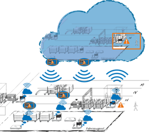
In this scenario, the creation of a fleet-wide environment information system can be a solution.
The sensor data will not to be evaluated locally on each AMR separately but collected on a server and then processed collectively.
An environment information system is to be developed that is generated collectively by all robots in the fleet and can be used jointly, containing not only metric but also semantic data. In addition to a suitable method for map generation, this also requires a strategy for coordinating write and read permissions. Furthermore, the sensor data should be transmitted to the server in as raw a form as possible. To save bandwidth, suitable compression is therefore probably required.
Such a model offers various potentials:
- The collective evaluation of sensor data behaves similarly to an extended sensor range. For example, it is possible to better cover critical danger areas if more than one robot is present there.
- Since all robots can locate themselves and other robots of the fleet in the common map at any time, blockades, for example, can be avoided in advance. This results in improved possibilities for coordination and thus potentially an increase in efficiency and process stability.
- A more precise understanding of the environment can also lead to a reduction in the potential danger for people in intralogistics. If all sensors in the fleet are considered, it is possible to track people over a larger area depending on the robot density. This means that predicted walking paths of people can be taken into account at an early stage in the path planning of the robot.
- Provided that a critical number of robots use an extensive sensor setup, it is conceivable that other robots in the fleet could "share" this setup. These robots could then rely on less elaborate sensors and still navigate safely. A lower financial investment in hardware would be possible.
One of the core elements of the collective environment information system is the communication of sensor data. For this, the type and scope of the transmitted data must be defined. This communication between the robot and the server should be published in a proposal for standardization.
The KolUmBot project has a duration of 2 years and 2 months. For structured processing, it is divided into seven work packages.
First, the requirements for the system are defined. These are determined by analyzing the state of the art and research and interviewing experts.
Then a concept for the collective information system is developed. The goal is to elaborate and describe all necessary components and interfaces.
In the third work package, a 3D data model will be developed for a generally valid, geometric and semantic mapping of the environment. For this purpose, all entities relevant to the environment information system with logistics reference (e.g. halls, shelves, aisles, people, industrial trucks or pallets) will be collected and their attributes and relationships will be determined by literature research and expert interviews.
Subsequently, strategies for the management of input and output data are defined. For data consolidation without contradictions, the fusion of different types of environment data into an actual state of the environment via consensus building is necessary. Furthermore, strategies for the distribution of updates to the environment are elaborated.
After the concept has been prepared, a demonstrator implementation of the system is planned. The software demonstrator will be set up on test hardware equipped with sufficient computing and transmission capacity. At the end of the work package, a functional environment information system will be available.
The developed demonstrator will then be evaluated. In particular, it will be checked whether the requirements determined at the beginning have been fulfilled. In cooperation with industrial partners, case studies will be created that will enable application-oriented tests with the environment information system.
Ongoing information events will be organized during the project to inform as many companies as possible about the results. After completion of the project, the developed environment information system will be made available to the public without discrimination in the form of the software demonstrator.
The following partners from industry take part in the project:
- AGILOX Services GmbH
- BMW AG
- Brose Fahrzeugteile SE & Co.
- Jungheinrich AG
- KS Control GmbH
- Magazino GmbH
- Noyes Technologies GmbH
- robominds GmbH
- Schiller Automatisierungstechnik GmbH
The research project IGF-project 22665 N of the Forschungsvereinigung Bundesvereinigung Logistik (BVL) e.V. is funded via AiF in the context of the German Federation of Industrial Research Associations (IGF) by the Federal ministry for Economic Affairs and Climate Action due to a Resolution of the German Bundestag.